Everyone has climbed South Sister. Or at least, in Bend is seems that way. But how many people have camped on South Sister? Not many. And, how many have camped on the actual summit of South Sister, 10, 358 feet above sea level and 6,735 feet above Bend? Even less.
A night on South Sister does not come easy. While the hike from the Devil’s Lake Trailhead is just five miles, the vertical rise is nearly 5,000 feet. The trail is well marked and well-trodden, with spectacular views in all directions. A Northwest Forest permit is required to park at the Devil’s Lake Trailhead. An option is to park on the Cascade Lakes Highway. Be warned – there are frequent break-ins of cars parked on the highway.

From the Devil’s Lake trailhead, the South Sister trail quickly crosses the Cascade Lakes Highway and enters a dense hemlock forest. Pick up your free Wilderness Permit here, making sure you specify your intent to spend the night on South Sister. If you did not bring full water bottles, fill up here at the year-round creek. The water is excellent. From here on, water is seasonal or a ways off the trail.
Climbing South Sister
As the trail ascends the canyon, it remains in thick forest, constantly climbing and zig-zagging up in switchbacks. One and a half miles later, you leave the canyon and step on the Moraine Lake Pumice Plateau. Finally, you can see your destination immediately ahead, dominating your view as it looms overhead.
Looking behind you and to the immediate south, Mount Bachelor rises before your eyes. It is easy to pick out your favorite ski runs on Northwest Express and Outback Express. Typically, there is snow on Bachelor well into August. Just over Mount Bachelor’s right shoulder, Diamond Peak is clearly visible. And beyond that, Mount Thielsen and Mount Scott can be seen. To the west, the Cascade foothills roll to the Coast range. Broken Top, South Sister’s nearest neighbor, provides a colorful scene to the east, displaying its multiple hues of lava like a rockbound rainbow.
After a mile across the plateau, the trail begins a relentless ascent towards the summit. The path varies from soft forest floor to scree to bouldering up steep slopes. Watch for the trail markers – dead trees or poles held vertically within large stone cairns. In spots, the trail offers several routes; don’t worry, all lead to the same place.

Soon, you will crest a moraine through an obvious saddle and be looking directly at the Lewis Glacier and its small cirque lake. The water is eerily emerald green due to glacial sediment. A short hike down a steep slope will take you to its frigid waters. The water is safe to drink once treated, but a little grainy. Water from lower snowfield melt streams is preferred, although scarce after mid-August.
Above this natural rest spot, the trail takes on a different character. The trail is now purely scree, the rocks vary from green to gray to yellow to red, and every step seems steeper. There are no trees for shady respite, and the summer sun may be very warm. All distances are, unfortunately, further than they look. Make sure you have full water bottles and take your time.
When you reach the final Red Traverse, you are very close to the summit plateau. Now, you will be surprised. The South Sister summit is actually a huge snow-covered plateau, over a quarter-mile across. The true summit (of course!) is on the far side. You may either cross straight over the summit snowfield, conditions allowing, or hike around counter-clockwise on the rocky ridge, which offers a somewhat smooth route.
Camping on the Summit
Summit views are worth the short hike. To the north, you look directly at Middle Sister and North Sister, Mount Washington, Three Fingered Jack, Mount Jefferson, Mount Hood, and Mount Adams. Casting your eyes downward, you look straight down the Prouty Glacier to the strangely green Carver Lake, sitting in a moon-like pumice desert.

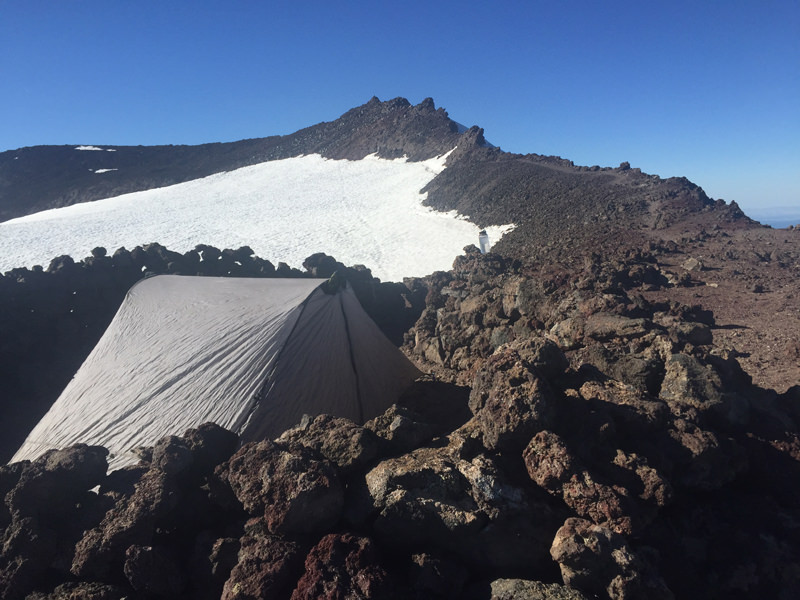
As you look around the summit ridge, you will notice about a half dozen rock-walled structures encircling level camp sites. The wind shelters nearest the summit trail saddle are cruder and less level. The preferred site is the final shelter (going counter-clockwise). This shelter has a smooth floor, accepts tent stakes, and is the highest in elevation, allowing unobstructed sunset and sunrise views. On even a calm, warm day, there can be a stiff, cold wind on the summit, so be prepared to be chilled.
Usually, you will have the summit to yourself for the night, although there may be another small group. But the area is large enough that you will likely not hear or see them.
Normally, water can be obtained from melt water on the edges of the summit snowfield. In the event that the snowfield is still solid, a short hike to its lowest point will take you to the highest lake in Oregon, the Teardrop Pond. If it is cold, it may be necessary to break the top ice layer to reach water.

Night skies on South Sister are clearly amazing. With little ambient light, the Milky Way jumps out. Easy to find constellations can be obscured by the tremendous number of visible stars. On a full moon night, you can read a book without a flashlight. Temperatures will typically be below freezing nightly, so be prepared for cold, even in August.
The descent is easy. Make sure you begin the descent where you crossed onto the summit plateau. A common mistake is to start down too far west, and venture onto the cliffs above the Lewis Glacier. Make sure you begin your descent no later than 4:00 PM, as the lower forests can get very dark after 8:00 PM.

While the South Sister mileages are rather tame, the trail feels twice the distance, due to the steepness. Plan accordingly. A night on the summit will be worth the effort, with long memories of endless views, solitude, sparkling stars, and more solitude. Bring a bottle of Good Life Sweet As and enjoy the good life.
Tips for Camping on South Sister
- Ascent can take from 3 ½ to 5 hours, descent from 2 ½ to 5 hours.
- Bring more water than you think you will need and water purification system.
- You will need a backpack, good sleeping bag, sleeping pad, tent, and cold weather clothes.
- No technical climbing experience or equipment is needed.
- Pack out all trash, including used TP.
- Cell phone service is available on the summit and portions of the trail.
- Less than five miles from the Devil’s Lake Trailhead to Elk Lake Resort for great post-hike burgers.


Responses
THANK YOU FOR THIS POST! THIS WAS GREAT TO READ, AS MY SON AND I ARE DOING THIS IN EARLY AUGUST 2019. WE WILL LET YOU KNOW HOW IT GOES. – HOWARD FROM MICHIGAN
What I meant is that we are camping at the summit. It should be EPIC!