The Wahclella Falls loop hike is much easier to complete than the name of this two tier waterfall is to pronounce. Also known as Tanner Creek Falls, Wahclella Falls is one of the most picturesque falls in all of the Columbia Gorge. The hike consists of a short “lollipop” loop that takes you through an incredible canyon lined with sheer cliffs and overhangs with Wahclella Falls at its pinnacle.
Who Would Enjoy Wahclella Falls
This hike is very popular for beginner hikers and tourists not from the area. It is very easy to get to and Wahclella Falls is less than a mile away from the trail head parking area. There is some mild exposure to cliffs on a few sections of the trail however compared to the rest of the hikes in this area of the Columbia Gorge it seems minimal making this a good hike if you are with children or bringing a dog.
Why Hike to Wahclella Falls
Wahclella Falls is truly one of the more beautiful spots in the Columbia River Gorge. It is easy to get to and offers so much to look at in what almost seems like a playground for the nature lover. For the experienced hiker this would be a very easy trek to complete and could even be done in conjunction with another hike. This hike is something that should be checked off everyone’s list that are familiar with the Gorge.
The Hike
The Wahclella Falls hike begins at a paved trail head just off highway 84 outside Cascade Locks. There is a restroom at the trail head and you must either display a NW Forest Pass or pay for day use at the parking kiosk.
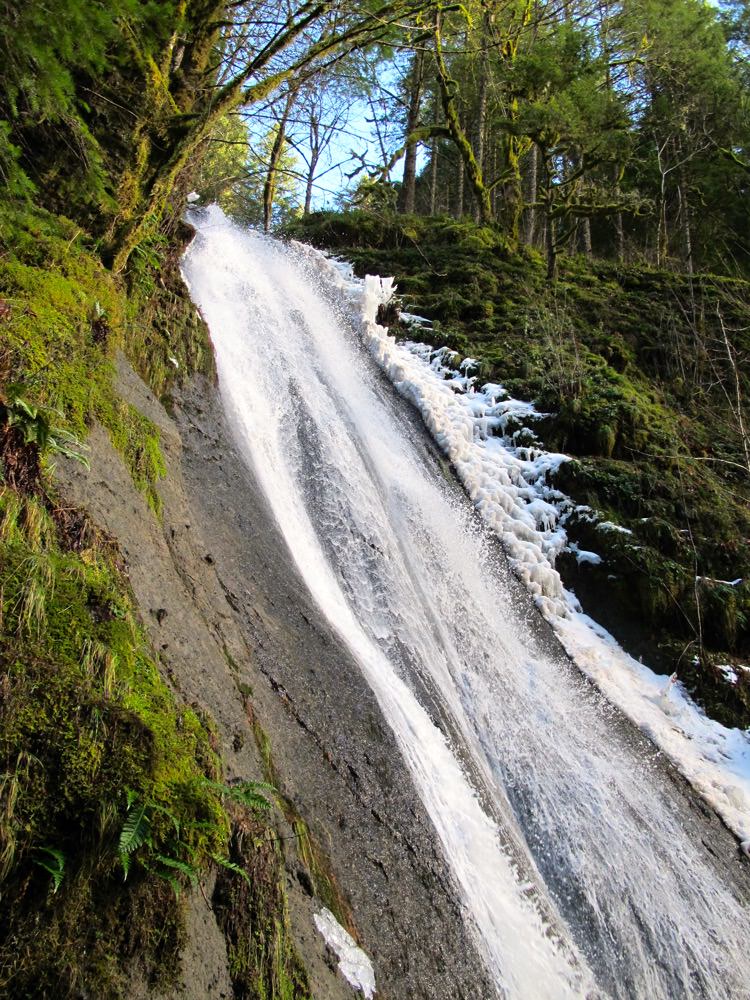
You will being your hike by paralleling Tanner Creek up a short access road to a fish hatchery dam. As soon as you reach the end of this road you will be on the trail. Almost as if a reward for reaching the trail you will be greeted by Munra Falls, a 68 foot waterfall that rushes so closely to the trail you can reach out and touch it.
From here the trail continues mildly up the canyon and beneath the cliffs until your reach a junction in which you can choose to go left or right. It does not matter which way you go as this is a loop. Left takes you to Wahclella Falls and right takes you to Wahclella Falls. So make like Robert Frost and see if you can pick the road less traveled (hint, it is impossible they are equally traveled). For the sake of this write-up we are going to go left.
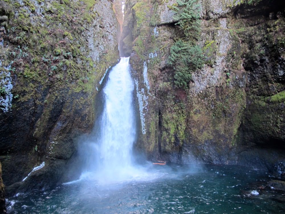
You will continue shortly up the mild canyon, ascend brief flight of stairs then descend to Wahclella Falls. From the junction the waterfall is less than 5 minutes away if you hike at a regular speed. Take pictures, go to the base of the falls, let your pooch go for a swim and enjoying the cooling mist of Wahclella Falls.
Moving on you will want to continue looking back at the falls as there is second tier to Wahclella Falls that is difficult to see from the base. When you cross the bridge look back for another great view. From here you will pass a rocky overhang that resembles a small cave and then follow the trail back to the junction.
A Note About Safety
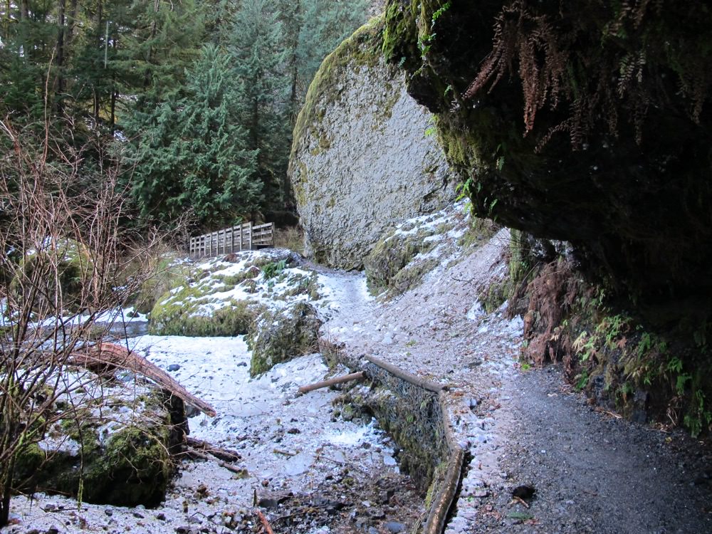
This hike follows a trail that is located at the foot of cliffs the entire way. On this hike you will see evidence of rock falls and debris coming down from above you. This is especially true during the depths of winter when ice forms on the cliffs and melts when it gets warm. We completed this hike in January during a thaw following a very ice period. When we reached the area of the hike where the trail goes by a small cave a very large sheet of ice came loose from the cliffs above us and landed directly on the trail. We cheated death by 10 seconds and a lot of luck.
Please keep in mind that anytime you hike in the Gorge it is a good idea to always pay attention to the cliffs above you no matter what time of year it is. Loose rock and debris is constantly coming down and hanging out under cliffs longer than you need to is a bad idea.
How to get to Wahclella Falls
This is probably one of the easier trail heads to find. Heading both east or west on Highway 84 you want to take exit 40 for Bonneville Dam. If you are coming from the west (Portland) you will take the first right after exiting the highway and then another hard right down a slight hill until you find the trail head parking lot.
Coming from the east (Hood River) again take exit 40 for Bonneville Dam and then take a left after exiting the highway crossing underneath the overpass. Once you pass under the highway take your first right down the short hill to the parking lot.
A Northwest Forest Pass is required or you can purchase a day pass at the kiosk.
Adventure Stats
- Hike Difficulty: Easy
- Hike Distance: 2 miles round trip
- Congestion: Very Busy
- Trail head Fee: Yes
- Best time to visit: After rainfall during mid week or early morning
Other Resources


Responses